Idalia live updates: Flooding, lashing winds predicted to hit Beaufort County

UPDATED AUGUST 29, 2023 9:41 AM Tropical Storm Idalia in the Caribbean off the coast of Cuba at 12 p.m. Monday, Aug. 28, 2023. NOAA National Hurricane Center
IDALIA STRENGTHENS TO A HURRICANE TUESDAY MORNING Updated 8:30 a.m. by Sarah Haselhorst / shaselhorst@islandpacket.com
Early Tuesday morning Idalia strengthened to a hurricane over the Gulf of Mexico after it scraped Cuba’s western shoreline, according to the National Hurricane Center. Forecasters expect Idalia will ramp up to a Category 3 hurricane on Wednesday morning when it makes landfall along the west coast of the Big Bend region of Florida, the center said. As of 8 a.m. Tuesday, Idalia was about 325 miles south-southwest of Tampa, the center reported. Idalia was heading north at 14 mph, with maximum sustained winds up to 80 miles per hour. In the Lowcountry, a 6 a.m. a Tuesday briefing from the National Weather Service’s Charleston Office reported Idalia would track near the coast as a Tropical Storm late Wednesday morning through Thursday morning. Heavy rainfall, between 4 and 8 inches, flash flooding and storm surge with high tide remained possible effects from Idalia. A moderate-to-high probability of tropical storm force winds remains, especially along the coast, NWS said. Dangerous rip currents, high surf and significant beach erosion are possible. A risk for tornadoes remains for the state’s southeast coast throughout Wednesday. Tropical Storm and Storm Surge watches were in place for Beaufort County on Tuesday morning. Throughout Wednesday, the county will be under a Flood Watch. A rip current statement also remains in place. Watches indicate the threat is possible somewhere within the area within the next 48 hours. “Details regarding the track, intensity, and timing of Idalia are still being refined,” the service reminded. Hurricane Franklin, a Category 4 hurricane, remains “formidable,” however it’s not expected to make landfall again. But its wake still makes for life-threatening surf and and rip currents along the southeast coastline, the National Hurricane Center reported.
Here are the Key Messages for Hurricane Idalia for the Tuesday am advisory. #Idalia is expected to intensify into an extremely dangerous major hurricane before landfall along the west coast or Big Bend region of Florida. More: http://hurricanes.gov
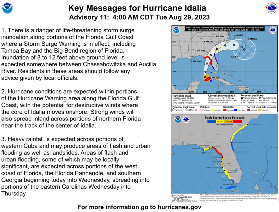
While Tropical Storm Idalia hadn’t strengthened into a hurricane as it moved in the Caribbean Sea, the storm was packing winds of 70 mph Monday afternoon. The National Hurricane Center expects Idalia to move into the Gulf of Mexico and become a major hurricane that will make landfall in Florida early Wednesday. Forecasters say Idalia’s landfall will be near Horseshoe Beach, a western shift in the track, according to Miami Herald reporting. However, meteorologists said “the track will continue to flip-flop east and west as the storm approaches.” In the Lowcountry, effects from Idalia could be seen as early as Tuesday evening with the height of concern throughout Wednesday, according to the National Weather Service Charleston Office’s Meteorologist Ron Morales. Morales said impacts from Idalia are increasing for the Lowcountry, with wind, storm surge, flooding rain and marine conditions as the main concerns. He added that the area Idalia is headed for in the Gulf is “notorious for rapid intensification.” After Idalia makes landfall, the storm is predicted to cross the “Florida Panhandle through, maybe, the southeast portion of Georgia and then really kind of (scrape) all along our coasts,” Morales said during a Monday evening briefing. However, he warned not to focus on the exact track this far out. According to the current forecast, there’s a potential for 58 to 73 mph winds along the southeast South Carolina coast. Morales said to “at least” prepare for low-end hurricane wind gusts. The greatest impact for storm surge is expected to happen Wednesday night with high tide. In Beaufort County, without the rainfall, high tide will swell to 9.1 feet at about 9:30 p.m. The highest potential shows water above normally-dry ground rising up to 3 feet. “Not everywhere will get the same amounts (of rainfall),” Morales said. “Some may get lucky and the winds are offshore … during high tide Wednesday evening. So not everybody will experience it. Some will get worse than others. We just don’t know where yet.” There is a potential threat for isolated tornadoes, the meteorologist added, but it depends if the storm tracks more inland. The more inland Idalia’s wake is felt, the higher the threat for tornadoes. “Again, these are potentials that we want to prepare for,” Morales reiterated. The State Climate Office’s severe weather liaison Frank Strait wrote in a Monday evening email that how much storm surge will impact the South Carolina’s coast “will depend on the timing, track, and intensity of Idalia” moving through the state. Strait explained that storm surge is a big concern because the area is entering a period of high astronomical tides. According to tide charts via the US Harbors site, Beaufort County’s Wednesday morning high tide will reach 8.2 feet at about 9 a.m. The evening high tide at 9:30 p.m. will swell to 9.1 feet. Thursday morning’s 9:50 tide is predicted to reach 8.6 feet. Those values are without potential rainfall amounts from Idalia. “The bottom line here is that the surge could be worse than forecast and you should be paying close attention to the storm surge forecast for your area if you’re a coastal resident,” Strait wrote. TROPICAL STORM, STORM SURGE WATCHES TRIGGERED Updated 5:30 p.m. by Sarah Haselhorst / shaselhorst@islandpacket.com Awaiting still-Tropical Storm Idalia, Tropical Storm and Surge watches were triggered for Beaufort County at 5:07 p.m. Monday. A Storm Surge Watch means life-threatening inundation, from rising water moving inland from the coastline is possible somewhere within the county within the next 48 hours, according to the National Weather Service. As of Monday early evening, peak surge inundation was between 2 and 4 feet above ground somewhere within surge prone areas. The service outlined Wednesday afternoon and Thursday morning as windows of concern. Storm surge flooding can damage buildings near the coast, roads, marinas, docks boardwalks and piers. Peak rainfall amounts will accumulate between 3 and 6 inches, with locally higher amounts, the NWS said. Streets and parking lots could become flooded, and drinking water and sewer services could be negatively impacted. “Water will be the big issue for the Carolinas from #Idalia Rainfall + Surge + King Tides, and don’t forget #Franklin is still sending swells towards the coast as well,” wrote Charlotte, North Carolina, meteorologist Brad Panovich in a Facebook post. The rainfall totals are really high here & with onshore flow & surge water trying to move out of rivers runs into the surge. Water levels are going to be high.” Panovich warned residents in flood-prone areas to begin making plans to move inland or to higher ground. A Tropical Storm Watch indicates that tropical storm-force winds are also possible within the next 48 hours, the National Weather Service said. The NWS predicted peak winds could reach 45 to 60 mph with gusts to 70 mph. The window of concern was Wednesday afternoon until early Thursday morning. Hazardous winds can cause roof and structural damage, snapped or uprooted trees, airborne projectiles, impassable roads, and power and communication outages. A rip current statement is also in effect until 8 p.m. Wednesday. RAINFALL, WINDS BIGGEST CONCERN Updated 11:40 a.m. by Sarah Haselhorst / shaselhorst@islandpacket.com Monday morning, Tropical Storm Idalia brewed near the western tip of Cuba on Monday morning, with the forecasters predicting the storm to soon strengthen to a hurricane, and had maximum sustained winds of 65 mph. Beaufort County could get between 4 and 8 inches of rain, strong, gusty winds, flooding, dangerous rip currents and severe erosion could pummel the Lowcountry beginning Wednesday evening, according the National Weather Service Charleston Office. During a Monday morning National Weather Service Charleston Office briefing, Meteorologist Steven Taylor said Lowcountry weather conditions will begin to “steadily deteriorate” Wednesday and peak in the evening and into early Thursday. “If the winds stay onshore and the system ends up being slower, the risk for coastal flooding and significant impacts will increase along parts of the Georgia coast and linger even longer up in the lower South Carolina coast,” Taylor said. The “big concern” from Idalia’s wrath will be rainfall and freshwater flooding, which when considering the already-high tides, could devolve into “major flooding,” Taylor said. Marine conditions, including dangerous rip currents that are currently rippling along the southeast coast, will also be of concern. Beaufort County was at a moderate risk for flash flooding and potential tornadoes throughout Wednesday, according to the local service Monday.
Read more at: https://www.islandpacket.com/news/weather-news/article278705294.html#storylink=cpy